
Make a donation
Aldekerk topographic map
Click on the map to display elevation.
Make a donation
About this map
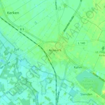
Name: Aldekerk topographic map, elevation, terrain.
Average elevation: 33 m
Minimum elevation: 27 m
Maximum elevation: 42 m
Make a donation
Other topographic maps
Click on a map to view its topography, its elevation and its terrain.
Kleve
Deutschland > Nordrhein-Westfalen > Kreis Kleve > Kleve
Kleve gehört geografisch zur Unteren Rheinniederung und zu den Niederrheinischen Höhen, beides Teile des Niederrheinischen Tieflands.
Average elevation: 39 m
Emmerich am Rhein
Deutschland > Nordrhein-Westfalen > Kreis Kleve
Emmerich gehört geographisch zur Unteren Rheinniederung, einem Teil des Niederrheinischen Tieflands. Die Innenstadt liegt auf einer Höhe von 17 Metern über NN. Der tiefste Punkt des Stadtgebietes liegt im Rheinvorland mit 13 Metern. Der Eltenberg mit einer Höhenlage bis zu 82 Metern wird der…
Average elevation: 18 m
Goch
Deutschland > Nordrhein-Westfalen > Kreis Kleve
Für das Jahr 2019 gab das Statistische Landesamt für die Stadt Goch eine Verschuldung-pro-Kopf in Höhe von 2967 Euro (insgesamt 101 032 208 €) und damit die höchsten Schulden im Kreis Kleve an. Das entspricht einer Steigerung von 28,4 % im Vergleich zum Jahr 2009.
Average elevation: 24 m
Make a donation
Kalkar
Deutschland > Nordrhein-Westfalen > Kreis Kleve
In der vorletzten Eiszeit (Saaleeiszeit) drangen Gletscher bis an den Niederrhein vor. Hier schoben sie Ablagerungen des Rheins zu Stauchmoränen auf. Zu ihnen gehört der Niederrheinische Höhenzug im Westen des Kalkarer Stadtgebiets. Der Rhein wurde von der Eisfront nach Südwesten abgedrängt.
Average elevation: 22 m
Kevelaer
Deutschland > Nordrhein-Westfalen > Kreis Kleve
War Kevelaer von der Märzrevolution noch kaum betroffen, so änderte sich dies 1871 durch den vom Reichskanzler Otto von Bismarck initiierten Kulturkampf. Zwischen 1871 und 1873 wurden der Kanzelparagraph eingeführt, der Jesuitenorden verboten und zum Höhepunkt des Kulturkampfes die Maigesetze erlassen. Im…
Average elevation: 24 m
Make a donation
Rheurdt
Deutschland > Nordrhein-Westfalen > Kreis Kleve
Rheurdt liegt linksrheinisch im niederrheinischen Tiefland auf einer Höhe von 30 bis 80 m ü. NN. Durch das Gemeindegebiet fließen die Nenneper Fleuth, der Littardsche Kendel und der Landwehrbach. In Nord-Süd-Richtung verlaufen die Rheurdter und Schaephuysener Höhen, eine Endmoräne aus der Saaleeiszeit.
Average elevation: 36 m
Uedem
Deutschland > Nordrhein-Westfalen > Kreis Kleve
Blasonierung: In Rot die silberne (weiße) Torburg mit drei Türmen, deren mittlerer breiter und höher ist als die begleitenden Seitentürme. Auf den Dächern goldene (gelbe) Knäufe, im offenen Tor goldenes (gelbes) Fallgitter. An der Stirnseite des Mittelturms das Klever Landeswappen mit seiner Helmzier…
Average elevation: 31 m
Make a donation
Make a donation
Kleve
Deutschland > Nordrhein-Westfalen > Kreis Kleve
Kleve gehört geografisch zur Unteren Rheinniederung und zu den Niederrheinischen Höhen, beides Teile des Niederrheinischen Tieflands.
Average elevation: 24 m
Make a donation
Ferienpark Kevelaer
Deutschland > Nordrhein-Westfalen > Kreis Kleve > Kevelaer > Schravelnsche Heide
Average elevation: 21 m
Make a donation
Kalkar
Deutschland > Nordrhein-Westfalen > Kreis Kleve
In der vorletzten Eiszeit (Saaleeiszeit) drangen Gletscher bis an den Niederrhein vor. Hier schoben sie Ablagerungen des Rheins zu Stauchmoränen auf. Zu ihnen gehört der Niederrheinische Höhenzug im Westen des Kalkarer Stadtgebiets. Der Rhein wurde von der Eisfront nach Südwesten abgedrängt.
Average elevation: 22 m
Make a donation
Goch
Deutschland > Nordrhein-Westfalen > Kreis Kleve
Für das Jahr 2019 gab das Statistische Landesamt für die Stadt Goch eine Verschuldung-pro-Kopf in Höhe von 2967 Euro (insgesamt 101 032 208 €) und damit die höchsten Schulden im Kreis Kleve an. Das entspricht einer Steigerung von 28,4 % im Vergleich zum Jahr 2009.
Average elevation: 24 m
Emmerich am Rhein
Deutschland > Nordrhein-Westfalen > Kreis Kleve
Emmerich gehört geographisch zur Unteren Rheinniederung, einem Teil des Niederrheinischen Tieflands. Die Innenstadt liegt auf einer Höhe von 17 Metern über NN. Der tiefste Punkt des Stadtgebietes liegt im Rheinvorland mit 13 Metern. Der Eltenberg mit einer Höhenlage bis zu 82 Metern wird der…
Average elevation: 18 m
Kleve
Deutschland > Nordrhein-Westfalen > Kreis Kleve
Kleve gehört geografisch zur Unteren Rheinniederung und zu den Niederrheinischen Höhen, beides Teile des Niederrheinischen Tieflands.
Average elevation: 24 m
Make a donation
Emmerich am Rhein
Deutschland > Nordrhein-Westfalen > Kreis Kleve
Emmerich gehört geographisch zur Unteren Rheinniederung, einem Teil des Niederrheinischen Tieflands. Die Innenstadt liegt auf einer Höhe von 17 Metern über NN. Der tiefste Punkt des Stadtgebietes liegt im Rheinvorland mit 13 Metern. Der Eltenberg mit einer Höhenlage bis zu 82 Metern wird der…
Average elevation: 18 m
Make a donation