
Thank you for supporting this site ❤️
Make a donation
Make a donation
Zourva topographic map
Click on the map to display elevation.
Thank you for supporting this site ❤️
Make a donation
Make a donation
About this map
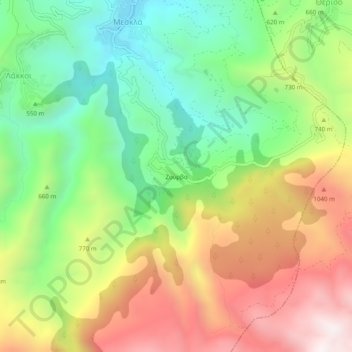
Name: Zourva topographic map, elevation, terrain.
Average elevation: 680 m
Minimum elevation: 185 m
Maximum elevation: 1,324 m
Thank you for supporting this site ❤️
Make a donation
Make a donation
Other topographic maps
Click on a map to view its topography, its elevation and its terrain.
Municipality of Kantanos-Selinon
Greece > Region of Crete > Chania Regional Unit
Average elevation: 389 m
Thank you for supporting this site ❤️
Make a donation
Make a donation
Municipality of Kantanos-Selinon
Greece > Region of Crete > Chania Regional Unit
Average elevation: 389 m
Thank you for supporting this site ❤️
Make a donation
Make a donation
Thank you for supporting this site ❤️
Make a donation
Make a donation
Thank you for supporting this site ❤️
Make a donation
Make a donation