
Thank you for supporting this site ❤️
Make a donation
Make a donation
Richmond Parish topographic map
Click on the map to display elevation.
Thank you for supporting this site ❤️
Make a donation
Make a donation
About this map
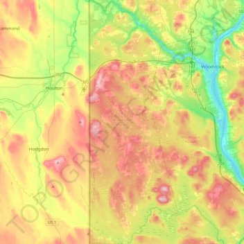
Name: Richmond Parish topographic map, elevation, terrain.
Location: Richmond Parish, Carleton County, New Brunswick, Canada (45.94279 -67.78174 46.22760 -67.63182)
Average elevation: 147 m
Minimum elevation: 36 m
Maximum elevation: 276 m
Thank you for supporting this site ❤️
Make a donation
Make a donation
Other topographic maps
Click on a map to view its topography, its elevation and its terrain.
South Knowlesville
Canada > New Brunswick > Carleton County > Town of Hartland
Average elevation: 285 m