
Cessnock topographic map
Click on the map to display elevation.
About this map
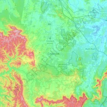
Name: Cessnock topographic map, elevation, terrain.
Average elevation: 142 m
Minimum elevation: -1 m
Maximum elevation: 580 m
Other topographic maps
Click on a map to view its topography, its elevation and its terrain.
Sydney
Sydney's topography is characterized by a diverse landscape that seamlessly blends coastal features with inland plateaus. The city is divided into two primary regions: the relatively flat Cumberland Plain to the south and west of Sydney Harbour, and the elevated Hornsby Plateau to the north. The Cumberland…
Average elevation: 53 m
Goulburn
Owing to its elevation, Goulburn has an oceanic climate (Cfb) with warm summers and cool winters; with a high diurnal range. Its climate is variable much of the year, though generally dry with maximum temperatures ranging from 11.8 °C (53.2 °F) in July to 28.3 °C (82.9 °F) in January. Rainfall is…
Average elevation: 666 m
Byron Bay
Byron Bay, located in northeastern New South Wales, Australia, is characterized by diverse topography shaped by its geological history. The town is part of the erosion caldera of the ancient Tweed Volcano, which erupted approximately 23 million years ago, resulting in the rich volcanic soils that define the…
Average elevation: 7 m
Mooney Mooney
Its topography is characterised by a rocky foreshore onto the Hawkesbury River and a hilly landscape with slopes ranging from moderate to very steep. Land use is dominated by the north–south transport corridors, comprising the M1 Pacific Motorway and the Pacific Highway, and two adjoining residential areas…
Average elevation: 32 m
Orange
Orange is a city in the Central Tablelands region of New South Wales, Australia. It is 254 km (158 mi) west of the state capital, Sydney [206 km (128 mi) on a great circle], at an altitude of 862 metres (2,828 ft). Orange had an estimated urban population of 40,493 as of June 2018 making the city a significant…
Average elevation: 852 m
Wentworth Falls
Australia > New South Wales > Sydney
Wentworth Falls (postcode: 2782) is a town in the Blue Mountains region of New South Wales, situated approximately 100 kilometres (62 mi) west of the Sydney central business district, and about 8 kilometres (5.0 mi) east of Katoomba, Australia on the Great Western Highway, with a Wentworth Falls railway…
Average elevation: 708 m
Canterbury-Bankstown Council
Australia > New South Wales > Sydney
Within the same year 16 US fighter planes that were based at Bankstown airport flew over Canterbury racecourse at low altitude during a race meet. This was to let the Australian public, especially those of the district to know that they, their allies were there for their protection. Regardless of these events,…
Average elevation: 26 m
Gundagai
Gundagai is an inland town with an elevation of 232 metres (761 ft). Almost all of the shire is located in the South West Slopes bio-region and is part of the Riverina agricultural region. The eastern part of the shire is considered part of the South Eastern Highlands bioregion.
Average elevation: 309 m
Leura
Leura's elevation of 985 metres (3,232 ft) AHD leads to occasional snowfall in winter and a climate that reflects all four seasons distinctly.
Average elevation: 880 m