
Thank you for supporting this site ❤️
Make a donation
Make a donation
Parroquia San Simón topographic map
Click on the map to display elevation.
Thank you for supporting this site ❤️
Make a donation
Make a donation
About this map
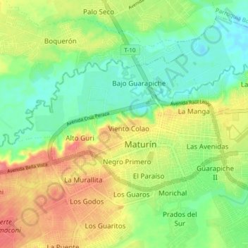
Name: Parroquia San Simón topographic map, elevation, terrain.
Average elevation: 59 m
Minimum elevation: 30 m
Maximum elevation: 96 m
Thank you for supporting this site ❤️
Make a donation
Make a donation
Other topographic maps
Click on a map to view its topography, its elevation and its terrain.
Thank you for supporting this site ❤️
Make a donation
Make a donation
Parque Andres Eloy Blanco
Venezuela > Estado Monagas > Municipio Maturín > Maturín
Average elevation: 50 m
Thank you for supporting this site ❤️
Make a donation
Make a donation
Río Guanipa
Venezuela > Estado Monagas > Municipio Maturín > Costa de La Iglesia
Average elevation: 47 m