
Thank you for supporting this site ❤️
Make a donation
Make a donation
Tainan topographic map
Click on the map to display elevation.
Thank you for supporting this site ❤️
Make a donation
Make a donation
About this map
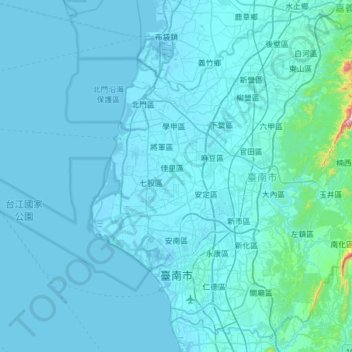
Name: Tainan topographic map, elevation, terrain.
Location: Tainan, Taiwan (22.88751 120.03477 23.41371 120.65626)
Average elevation: 24 m
Minimum elevation: -5 m
Maximum elevation: 772 m
Thank you for supporting this site ❤️
Make a donation
Make a donation
Other topographic maps
Click on a map to view its topography, its elevation and its terrain.
Yushan
Taiwan > Nantou County > Xinyi Township
Yu Shan or Yushan, also known as Mount Jade, Jade Mountain, Tongku Saveq or Mount Niitaka during Japanese rule, is the highest mountain in Taiwan at 3,952 m (12,966 ft) above sea level, giving Taiwan the 4th-highest maximum elevation of any island in the world. It is the highest point in the western Pacific…
Average elevation: 3,411 m
Thank you for supporting this site ❤️
Make a donation
Make a donation