
Thank you for supporting this site ❤️
Make a donation
Make a donation
Stalowa Wola topographic map
Click on the map to display elevation.
Thank you for supporting this site ❤️
Make a donation
Make a donation
About this map
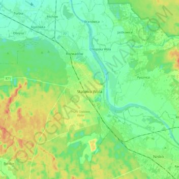
Name: Stalowa Wola topographic map, elevation, terrain.
Average elevation: 159 m
Minimum elevation: 143 m
Maximum elevation: 190 m
Thank you for supporting this site ❤️
Make a donation
Make a donation
Other topographic maps
Click on a map to view its topography, its elevation and its terrain.
Grzybowa Góra
Poland > Subcarpathian Voivodeship > Stalowa Wola County > Jastkowice
Average elevation: 174 m
Stalowa Wola
Poland > Subcarpathian Voivodeship > Stalowa Wola County > Stalowa Wola
Average elevation: 158 m