
Thank you for supporting this site ❤️
Make a donation
Make a donation
Jasper County topographic map
Click on the map to display elevation.
Thank you for supporting this site ❤️
Make a donation
Make a donation
About this map
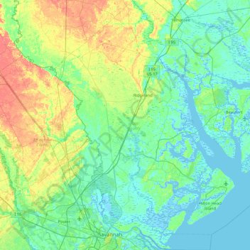
Name: Jasper County topographic map, elevation, terrain.
Location: Jasper County, South Carolina, United States (32.03345 -81.28124 32.75315 -80.74633)
Average elevation: 12 m
Minimum elevation: -6 m
Maximum elevation: 48 m
Thank you for supporting this site ❤️
Make a donation
Make a donation
Other topographic maps
Click on a map to view its topography, its elevation and its terrain.