
Thank you for supporting this site ❤️
Make a donation
Make a donation
Roberts Creek topographic map
Click on the map to display elevation.
Thank you for supporting this site ❤️
Make a donation
Make a donation
About this map
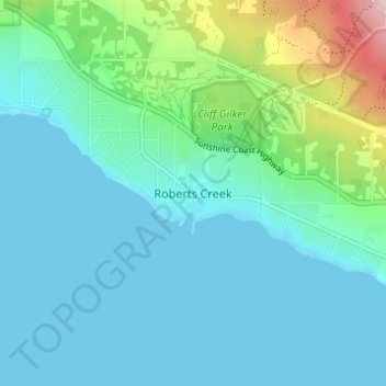
Name: Roberts Creek topographic map, elevation, terrain.
Average elevation: 56 m
Minimum elevation: -1 m
Maximum elevation: 317 m
Thank you for supporting this site ❤️
Make a donation
Make a donation
Other topographic maps
Click on a map to view its topography, its elevation and its terrain.
Chapman Lake
Canada > British Columbia > Sunshine Coast Regional District > Area D (Roberts Creek)
Average elevation: 1,111 m