
Make a donation
Weikersheim topographic map
Click on the map to display elevation.
Make a donation
Weikersheim
The township (Stadt) of Weikersheim covers 80.92 square kilometers (31.24 sq mi) of the Main-Tauber district of Baden-Württemberg, a state of the Federal Republic of Germany. Weikersheim is physically located in the Tauberland [de], a landscape of muschelkalk crossed by numerous river valleys, but especially the Tauber and Vorbach. The lowest elevation above sea level in the municipal area, 213 meters (699 ft) Normalnull (NN), is found on the Tauber, near Elpersheim [de]. The highest elevation, 444 meters (1,457 ft), is found to the south-east, near the border with Oberndorf (Weikersheim).
Make a donation
About this map
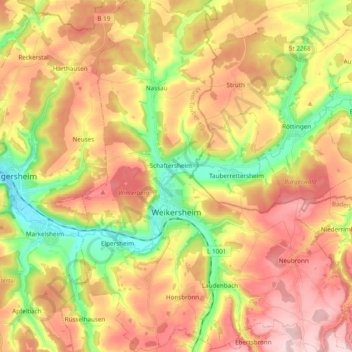
Name: Weikersheim topographic map, elevation, terrain.
Average elevation: 334 m
Minimum elevation: 208 m
Maximum elevation: 449 m
Make a donation
Other topographic maps
Click on a map to view its topography, its elevation and its terrain.