
Make a donation
Midwest City topographic map
Click on the map to display elevation.
Make a donation
Midwest City
Midwest City is located at 35°27′44″N 97°23′3″W / 35.46222°N 97.38417°W / 35.46222; -97.38417 (35.462244, -97.384292). According to the United States Census Bureau, the city has a total area of 24.6 square miles (64 km2), all land. The city's elevation is 1,157 feet above sea level.
Make a donation
About this map
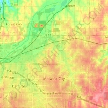
Name: Midwest City topographic map, elevation, terrain.
Location: Midwest City, Oklahoma County, Oklahoma, United States (35.43319 -97.42413 35.51516 -97.29061)
Average elevation: 371 m
Minimum elevation: 329 m
Maximum elevation: 405 m
Make a donation
Other topographic maps
Click on a map to view its topography, its elevation and its terrain.
Newalla
United States > Oklahoma > Oklahoma County > Oklahoma City
Newalla, with a current elevation of 1,148 feet, is located within the Eastern bounds of Oklahoma County and appears on the Harrah, Oklahoma U.S. Geological Survey Map due to their proximity. Newalla is a geographic area which spans unincorporated Oklahoma County and unincorporated Cleveland County (also…
Average elevation: 343 m
Make a donation
Lightning Creek Holding Pond B Dam
United States > Oklahoma > Oklahoma County > Oklahoma City
Average elevation: 386 m
Make a donation