
Thank you for supporting this site ❤️
Make a donation
Make a donation
Waratah-Wynyard topographic map
Click on the map to display elevation.
Thank you for supporting this site ❤️
Make a donation
Make a donation
About this map
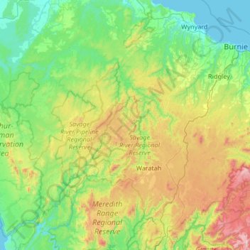
Name: Waratah-Wynyard topographic map, elevation, terrain.
Location: Waratah-Wynyard, Tasmania, Australia (-41.70763 145.06266 -40.90241 145.85325)
Average elevation: 347 m
Minimum elevation: -2 m
Maximum elevation: 1,520 m
Thank you for supporting this site ❤️
Make a donation
Make a donation
Other topographic maps
Click on a map to view its topography, its elevation and its terrain.
Thank you for supporting this site ❤️
Make a donation
Make a donation
Thank you for supporting this site ❤️
Make a donation
Make a donation
Thank you for supporting this site ❤️
Make a donation
Make a donation