
Thank you for supporting this site ❤️
Make a donation
Make a donation
Vilnius County topographic map
Click on the map to display elevation.
Thank you for supporting this site ❤️
Make a donation
Make a donation
About this map
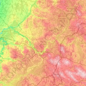
Name: Vilnius County topographic map, elevation, terrain.
Location: Vilnius County, Lithuania (54.12765 24.38667 55.51772 26.75936)
Average elevation: 146 m
Minimum elevation: 30 m
Maximum elevation: 317 m
Thank you for supporting this site ❤️
Make a donation
Make a donation
Other topographic maps
Click on a map to view its topography, its elevation and its terrain.