
Thank you for supporting this site ❤️
Make a donation
Make a donation
Ogliastra topographic map
Click on the map to display elevation.
Thank you for supporting this site ❤️
Make a donation
Make a donation
About this map
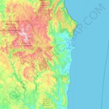
Name: Ogliastra topographic map, elevation, terrain.
Location: Ogliastra, Sardinia, Italy (39.54929 9.27837 40.22495 9.73557)
Average elevation: 403 m
Minimum elevation: -1 m
Maximum elevation: 1,818 m
Thank you for supporting this site ❤️
Make a donation
Make a donation
Other topographic maps
Click on a map to view its topography, its elevation and its terrain.
Torre Grande
Italy > Sardinia > Aristanis/Oristano > Aristanis/Oristano > Torregrande
Average elevation: 1 m
Salina di Sant'Antioco
Italy > Sardinia > Santu Giuanni Suèrgiu/San Giovanni Suergiu
Average elevation: 0 m