
Flores topographic map
Interactive map
Click on the map to display elevation.
About this map
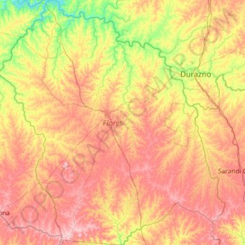
Name: Flores topographic map, elevation, terrain.
Location: Flores, Uruguay (-33.98479 -57.36087 -33.11902 -56.39648)
Average elevation: 109 m
Minimum elevation: 33 m
Maximum elevation: 202 m
Other topographic maps
Click on a map to view its topography, its elevation and its terrain.
Las Toscas
Uruguay > Canelones > Municipio de Parque del Plata
Las Toscas, Municipio de Parque del Plata, Canelones, 16002, Uruguay
Average elevation: 15 m
Kiyú - Ordeig
Uruguay > San José > Kiyú - Ordeig > Kiyú - Ordeig
Kiyú - Ordeig, San José, 80102, Uruguay
Average elevation: 14 m
Villa Felicidad
Uruguay > Canelones > Villa Felicidad
Villa Felicidad, Canelones, 15900, Uruguay
Average elevation: 44 m