
Thank you for supporting this site ❤️
Make a donation
Make a donation
Connell topographic map
Click on the map to display elevation.
Thank you for supporting this site ❤️
Make a donation
Make a donation
About this map
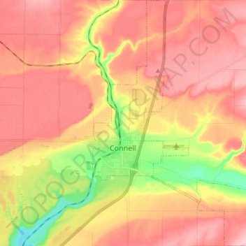
Name: Connell topographic map, elevation, terrain.
Location: Connell, Franklin County, Washington, 99326, United States (46.62004 -118.87961 46.72112 -118.78386)
Average elevation: 312 m
Minimum elevation: 218 m
Maximum elevation: 370 m
Thank you for supporting this site ❤️
Make a donation
Make a donation