
Cantón Cañas topographic map
Interactive map
Click on the map to display elevation.
About this map
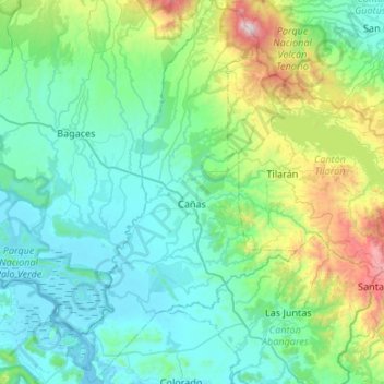
Name: Cantón Cañas topographic map, elevation, terrain.
Location: Cantón Cañas, Provincia Guanacaste, Costa Rica (10.18331 -85.24957 10.71610 -84.94878)
Average elevation: 322 m
Minimum elevation: -1 m
Maximum elevation: 1,885 m
Other topographic maps
Click on a map to view its topography, its elevation and its terrain.
Cantón Bagaces
Costa Rica > Provincia Guanacaste
Cantón Bagaces, Provincia Guanacaste, Costa Rica
Average elevation: 205 m