
Guímara topographic map
Interactive map
Click on the map to display elevation.
About this map
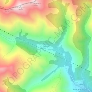
Name: Guímara topographic map, elevation, terrain.
Location: Guímara, Peranzanes, El Bierzo, León, Castilla y León, España (42.87930 -6.70969 42.91930 -6.66969)
Average elevation: 1,370 m
Minimum elevation: 956 m
Maximum elevation: 1,948 m
Other topographic maps
Click on a map to view its topography, its elevation and its terrain.
Fresnedelo
España > Castilla y León > El Bierzo > Peranzanes
Fresnedelo, Peranzanes, El Bierzo, León, Castilla y León, 24429, España
Average elevation: 1,070 m
Fornela
España > Castilla y León > El Bierzo > Peranzanes
Fornela, Peranzanes, El Bierzo, León, Castilla y León, 24429, España
Average elevation: 1,178 m
Trascastro
España > Castilla y León > El Bierzo > Peranzanes
Trascastro, Peranzanes, El Bierzo, León, Castilla y León, 24429, España
Average elevation: 1,181 m