
Piz Ault topographic map
Interactive map
Click on the map to display elevation.
About this map
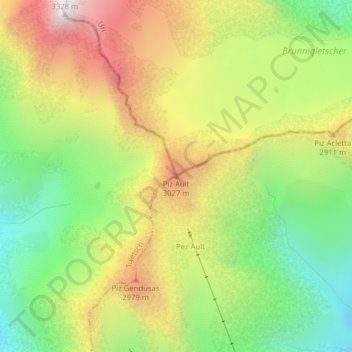
Name: Piz Ault topographic map, elevation, terrain.
Location: Piz Ault, Silenen, Uri, Svizzera (46.72826 8.78194 46.72836 8.78204)
Average elevation: 2,679 m
Minimum elevation: 2,198 m
Maximum elevation: 3,260 m
Other topographic maps
Click on a map to view its topography, its elevation and its terrain.
Gross Windgällen
Gross Windgällen, Silenen, Uri, 6475, Svizzera
Average elevation: 2,393 m
Piz Cazarauls
Piz Cazarauls, Silenen, Uri, Svizzera
Average elevation: 2,684 m