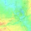
Wadsworth Township topographic map
Click on the map to display elevation.
About this map

Name: Wadsworth Township topographic map, elevation, terrain.
Location: Wadsworth Township, Medina County, Ohio, United States (40.98820 -81.78572 41.06227 -81.68763)
Average elevation: 351 m
Minimum elevation: 296 m
Maximum elevation: 399 m
Other topographic maps
Click on a map to view its topography, its elevation and its terrain.


Chippewa Creek Structure VIII-C Dam
United States > Ohio > Medina County > River Styx
Average elevation: 325 m