
Londres topographic map
Interactive map
Click on the map to display elevation.
About this map
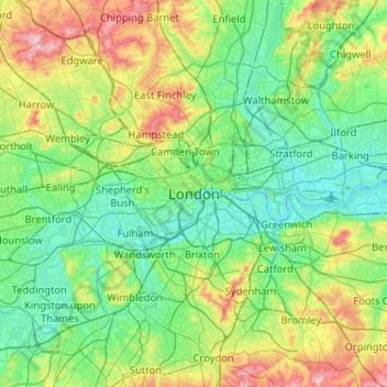
Name: Londres topographic map, elevation, terrain.
Location: Londres, Grand Londres, Angleterre, SW1A 2DX, Royaume-Uni (51.34732 -0.28765 51.66732 0.03235)
Average elevation: 42 m
Minimum elevation: -3 m
Maximum elevation: 163 m
L'altitude y varie du niveau de la mer jusqu'à 245 m (Biggin Hill, au sud de l'agglomération).
Other topographic maps
Click on a map to view its topography, its elevation and its terrain.
Lewisham
Royaume-Uni > Angleterre > Londres > Lewisham
Lewisham, Londres, Grand Londres, Angleterre, SE13 6BB, Royaume-Uni
Average elevation: 28 m