
Baghdati Municipality topographic map
Interactive map
Click on the map to display elevation.
About this map
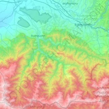
Name: Baghdati Municipality topographic map, elevation, terrain.
Location: Baghdati Municipality, Imereti, 1000, Georgia (41.80902 42.65419 42.19247 43.12703)
Average elevation: 947 m
Minimum elevation: 63 m
Maximum elevation: 2,838 m
Other topographic maps
Click on a map to view its topography, its elevation and its terrain.
Samtredia
Georgia > Imereti > Samtredia Municipality
Samtredia, Samtredia Municipality, Imereti, 3900, Georgia
Average elevation: 26 m
Sairme
Georgia > Imereti > Vani Municipality > Sairme
Sairme, Vani Municipality, Imereti, Georgia
Average elevation: 1,279 m