
Thank you for supporting this site ❤️
Make a donation
Make a donation
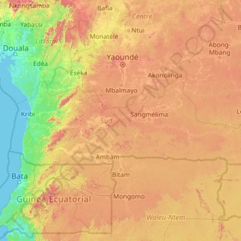
South topographic map
Click on the map to display elevation.
Thank you for supporting this site ❤️
Make a donation
Make a donation
South
The South Region begins at sea level on the coast. The land slowly climbs throughout the Kribi-Douala basin, which averages 300–600 metres in altitude, until it reaches the South Cameroon Plateau with elevations of 500 to 1000 metres above sea level. Rocky promontories on the coast and rolling, tree-covered hills inland characterize the land. The Ntem Massif near Ebolowa is the province's highest point at 1400 metres.
Thank you for supporting this site ❤️
Make a donation
Make a donation
About this map
Name: South topographic map, elevation, terrain.
Location: South, Cameroon (2.14317 9.58925 3.68304 13.67978)
Average elevation: 498 m
Minimum elevation: -1 m
Maximum elevation: 1,921 m
Thank you for supporting this site ❤️
Make a donation
Make a donation
Other topographic maps
Click on a map to view its topography, its elevation and its terrain.