
Thank you for supporting this site ❤️
Make a donation
Make a donation
Prices Fork topographic map
Click on the map to display elevation.
Thank you for supporting this site ❤️
Make a donation
Make a donation
About this map
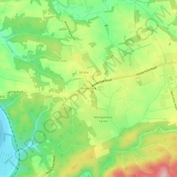
Name: Prices Fork topographic map, elevation, terrain.
Location: Prices Fork, Montgomery County, Virginia, United States (37.18985 -80.51005 37.22985 -80.47005)
Average elevation: 597 m
Minimum elevation: 513 m
Maximum elevation: 711 m
Thank you for supporting this site ❤️
Make a donation
Make a donation
Other topographic maps
Click on a map to view its topography, its elevation and its terrain.