
Schwende topographic map
Interactive map
Click on the map to display elevation.
About this map
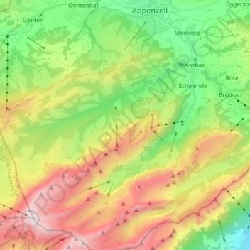
Name: Schwende topographic map, elevation, terrain.
Average elevation: 1,279 m
Minimum elevation: 446 m
Maximum elevation: 2,479 m
Other topographic maps
Click on a map to view its topography, its elevation and its terrain.
Brülisau
Suisse > Appenzell Rhodes-Intérieures > Schwende-Rüte
Rüte, Brülisau, Schwende-Rüte, Appenzell Rhodes-Intérieures, 9050, Suisse
Average elevation: 1,006 m