
Malappuram topographic map
Interactive map
Click on the map to display elevation.
About this map
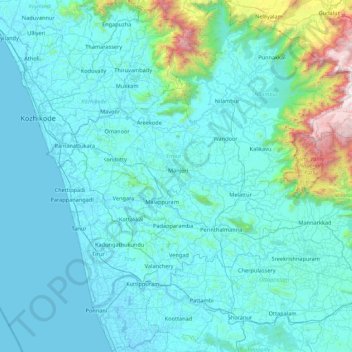
Name: Malappuram topographic map, elevation, terrain.
Location: Malappuram, Kerala, India (10.68412 75.82559 11.52928 76.54926)
Average elevation: 224 m
Minimum elevation: -5 m
Maximum elevation: 2,529 m
On the basis of topography, geology, soils, climate, and natural vegetation, the district is divided into 5 sub-micro regions:
Other topographic maps
Click on a map to view its topography, its elevation and its terrain.
Vaduvanchal
Vaduvanchal, Vythiri, Wayanad, Kerala, 673581, India
Average elevation: 858 m
Kalamassery
India > Kerala > Kanayannur
Kalamassery, Kanayannur, Ernakulam district, Kerala, 683104, India
Average elevation: 10 m
Vellamunda
Vellamunda, Mananthavady-Pakramthalam Road, Kavilumpara, Wayanad, Kerala, 670731, India
Average elevation: 864 m
Meesapulimala
Meesapulimala, Idukki, Kerala, 685618, India
Average elevation: 2,221 m