
Thank you for supporting this site ❤️
Make a donation
Make a donation
Schrozberg topographic map
Click on the map to display elevation.
Thank you for supporting this site ❤️
Make a donation
Make a donation
About this map
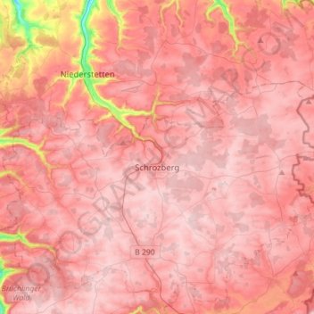
Name: Schrozberg topographic map, elevation, terrain.
Average elevation: 448 m
Minimum elevation: 268 m
Maximum elevation: 501 m
Thank you for supporting this site ❤️
Make a donation
Make a donation
Other topographic maps
Click on a map to view its topography, its elevation and its terrain.
Kleinallmerspann
Germany > Baden-Württemberg > Landkreis Schwäbisch Hall > Kirchberg an der Jagst
Average elevation: 430 m