
Make a donation
Cevicheria Umiña topographic map
Click on the map to display elevation.
Make a donation
About this map
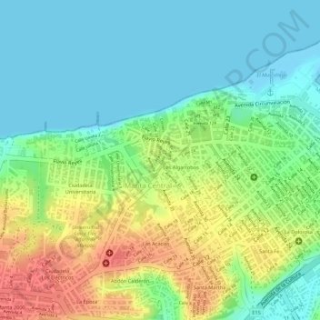
Name: Cevicheria Umiña topographic map, elevation, terrain.
Location: Cevicheria Umiña, Manta, Manabí, 130214, Ecuador (-0.94641 -80.73918 -0.94631 -80.73908)
Average elevation: 26 m
Minimum elevation: -2 m
Maximum elevation: 66 m
Make a donation
Other topographic maps
Click on a map to view its topography, its elevation and its terrain.
Manta
Manta, también conocida como San Pablo de Manta, es una ciudad ecuatoriana; cabecera del cantón homónimo, así como la urbe más grande y poblada de la Provincia de Manabí. Se localiza en la costa del océano Pacífico, al centro de la región litoral del Ecuador, a una altitud de 6 m s. n. m. y con un…
Average elevation: 78 m
Manta
Manta, también conocida como San Pablo de Manta, es una ciudad ecuatoriana; cabecera del cantón homónimo, así como la urbe más grande y poblada de la Provincia de Manabí. Se localiza en la costa del océano Pacífico, al centro de la región litoral del Ecuador, a una altitud de 6 m s. n. m. y con un…
Average elevation: 77 m
Make a donation
Manta
Manta, también conocida como San Pablo de Manta, es una ciudad ecuatoriana; cabecera del cantón homónimo, así como la urbe más grande y poblada de la Provincia de Manabí. Se localiza en la costa del océano Pacífico, al centro de la región litoral del Ecuador, a una altitud de 6 m s. n. m. y con un…
Average elevation: 78 m
Make a donation