
Thank you for supporting this site ❤️
Make a donation
Make a donation
Messina topographic map
Click on the map to display elevation.
Thank you for supporting this site ❤️
Make a donation
Make a donation
Messina
Located in the north-eastern corner of Sicily, on the western shore of the Strait of Messina (Ionian Sea)— altitude 3 m (9.8 ft) above sea level— it extends for 213.75 km2 (82.53 sq mi) of municipal surface. Its extension on the coast (56 km (35 mi) from the coast of Giampilieri to the south to that of Orto Liuzzo to the north), which makes it the "longest" and most maritime city in Italy.
Thank you for supporting this site ❤️
Make a donation
Make a donation
About this map
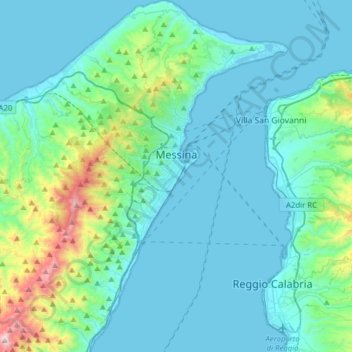
Name: Messina topographic map, elevation, terrain.
Location: Messina, Sicily, Italy (38.05551 15.40793 38.30149 15.65308)
Average elevation: 170 m
Minimum elevation: -2 m
Maximum elevation: 1,243 m
Thank you for supporting this site ❤️
Make a donation
Make a donation
Other topographic maps
Click on a map to view its topography, its elevation and its terrain.
Thank you for supporting this site ❤️
Make a donation
Make a donation
Thank you for supporting this site ❤️
Make a donation
Make a donation
Thank you for supporting this site ❤️
Make a donation
Make a donation
Thank you for supporting this site ❤️
Make a donation
Make a donation
Thank you for supporting this site ❤️
Make a donation
Make a donation
Thank you for supporting this site ❤️
Make a donation
Make a donation