
Thank you for supporting this site ❤️
Make a donation
Make a donation
Puerto Berrío topographic map
Click on the map to display elevation.
Thank you for supporting this site ❤️
Make a donation
Make a donation
About this map
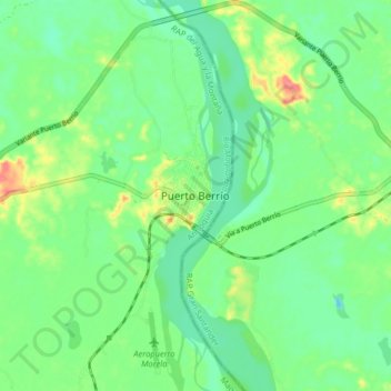
Name: Puerto Berrío topographic map, elevation, terrain.
Location: Puerto Berrío, Magdalena Medio, Antioquia, Colombia (6.44992 -74.44206 6.52992 -74.36206)
Average elevation: 109 m
Minimum elevation: 85 m
Maximum elevation: 159 m
Thank you for supporting this site ❤️
Make a donation
Make a donation
Other topographic maps
Click on a map to view its topography, its elevation and its terrain.