Geolocate

Queensville topographic map

Interactive map

Click on the map to display elevation.

About this map

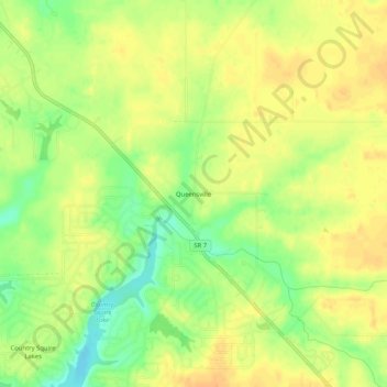
Name: Queensville topographic map, elevation, terrain.

Location: Queensville, Jennings County, Indiana, 47625, United States (39.03116 -85.69719 39.07116 -85.65719)

Average elevation: 214 m

Minimum elevation: 192 m

Maximum elevation: 227 m

Other topographic maps

Click on a map to view its topography, its elevation and its terrain.

Scipio

United States > Indiana > Jennings County

Scipio, Jennings County, Indiana, United States

Average elevation: 203 m

Gaylord Stark Lake Dam

United States > Indiana > Jennings County

Gaylord Stark Lake Dam, Jennings County, Indiana, United States

Average elevation: 237 m

Butlerville

United States > Indiana > Jennings County

Butlerville, Jennings County, Indiana, 47223, United States

Average elevation: 242 m

Lovett

United States > Indiana > Jennings County > Lovett

Lovett, Jennings County, Indiana, 47227, United States

Average elevation: 213 m