
Thank you for supporting this site ❤️
Make a donation
Make a donation
Cemaga topographic map
Click on the map to display elevation.
Thank you for supporting this site ❤️
Make a donation
Make a donation
About this map
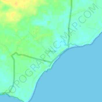
Name: Cemaga topographic map, elevation, terrain.
Location: Cemaga, Natuna, Riau Islands, Sumatra, Indonesia (3.76472 108.34194 3.80472 108.38194)
Average elevation: 6 m
Minimum elevation: 0 m
Maximum elevation: 24 m
Thank you for supporting this site ❤️
Make a donation
Make a donation
Other topographic maps
Click on a map to view its topography, its elevation and its terrain.