
Make a donation
Nazareth topographic map
Click on the map to display elevation.
Make a donation
Nazareth
Nazareth's climate is similar to the rest of the Lehigh Valley with four distinct seasons, humid summers, cold winters, and very short and mild springs and falls. This climate is hot-summer humid continental (Dfa) and average monthly temperatures range from 28.1 °F (−2.2 °C) in January to 73.4 °F (23.0 °C) in July. The hardiness zone is 6b. Nazareth's topography can best be described as hilly, as the town itself sits atop a local outcropping underground of one of the richest veins of limestone in the U.S. Much of the farmland surrounding Nazareth is being converted into close sitting lots of suburban housing, for predominantly commuter households.
Make a donation
About this map
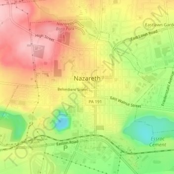
Name: Nazareth topographic map, elevation, terrain.
Average elevation: 149 m
Minimum elevation: 56 m
Maximum elevation: 224 m
Make a donation
Other topographic maps
Click on a map to view its topography, its elevation and its terrain.
Kreidersville
United States > Pennsylvania > Northampton County > Allen Township
Average elevation: 151 m
Illick's Mill Road Gateway
United States > Pennsylvania > Northampton County > Bethlehem
Average elevation: 105 m
Make a donation
Danielsville
United States > Pennsylvania > Northampton County > Lehigh Township
Average elevation: 254 m
Portlamd Waterfront Park
United States > Pennsylvania > Northampton County > Portland
Average elevation: 118 m
Weaversville
United States > Pennsylvania > Northampton County > East Allen Township
Average elevation: 129 m
Make a donation
Mount Bethel
United States > Pennsylvania > Northampton County > Upper Mount Bethel Township
Average elevation: 156 m
Martins Creek
United States > Pennsylvania > Northampton County > Lower Mount Bethel Township
Average elevation: 127 m
Moorestown
United States > Pennsylvania > Northampton County > Moore Township
Average elevation: 219 m
Make a donation
West Bangor
United States > Pennsylvania > Northampton County > Washington Township
Average elevation: 310 m
Morgan Hill
United States > Pennsylvania > Northampton County > Williams Township
Average elevation: 147 m
Leithsville
United States > Pennsylvania > Northampton County > Lower Saucon Township
Average elevation: 162 m
Mount Bethel
United States > Pennsylvania > Northampton County > Upper Mount Bethel Township
Average elevation: 156 m
Make a donation
Northwood Heights
United States > Pennsylvania > Northampton County > Palmer Township > Palmer Heights
Average elevation: 110 m
Brodhead
United States > Pennsylvania > Northampton County > Bethlehem Township
Average elevation: 115 m
Make a donation