
Make a donation
Wei-Assipu-tepui topographic map
Click on the map to display elevation.
Make a donation
Wei-Assipu-tepui
Wei-Assipu-tepui has a maximum elevation of around 2,400 metres (7,870 ft). Its summit plateau is highly dissected and generally inclined south-southwest (towards the Brazilian side). The rocky summit is partially forested, with flowering plants of the genus Bonnetia featuring prominently. It also hosts a number of carnivorous plants, including Heliamphora glabra, Heliamphora nutans, and the natural hybrid between the two. The various rock cavities of Wei-Assipu-tepui are home to nesting colonies of white-collared swifts (Streptoprocne zonaris) and oilbirds (Steatornis caripensis). For the latter species, Wei-Assipu-tepui is the easternmost recorded locality in mainland South America, and the first known nesting site in Brazil. The mountain's summit supports a greater variety of herpetofauna than the less vegetated plateaus of nearby Roraima-tepui, Kukenán-tepui, Yuruaní-tepui, and Ilú-tepui. Day temperatures of 17 °C (63 °F) have been recorded on the summit plateau, falling to 12 °C (54 °F) overnight, with slightly lower values in the more sheltered caves.
Make a donation
About this map
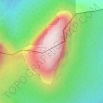
Name: Wei-Assipu-tepui topographic map, elevation, terrain.
Average elevation: 1,760 m
Minimum elevation: 1,357 m
Maximum elevation: 2,277 m
Make a donation