
Make a donation
Summit Hill topographic map
Click on the map to display elevation.
Make a donation
Summit Hill
According to the U.S. Census Bureau, Summit Hill borough has a total area of 9.1 square miles (23.6 km2), of which 8.7 square miles (22.5 km2) is land and 0.42 square miles (1.1 km2), or 4.54%, is water. Summit Hill is located 6 miles (10 km) southwest of Jim Thorpe and 1 mile south of Lansford. Summit Hill's elevation varies from 1,520 feet (460 m) above sea level in the borough center to 1,620 feet (490 m) at the highest point on Pisgah Mountain to 1,010 feet (310 m) at Mauch Chunk Lake.
Make a donation
About this map
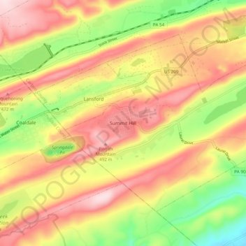
Name: Summit Hill topographic map, elevation, terrain.
Average elevation: 368 m
Minimum elevation: 197 m
Maximum elevation: 512 m
Make a donation
Other topographic maps
Click on a map to view its topography, its elevation and its terrain.
Holiday Poconos
United States > Pennsylvania > Carbon County > Kidder Township
Average elevation: 519 m
Make a donation
Hickory Run State Park
United States > Pennsylvania > Carbon County > Kidder Township
Average elevation: 471 m
Beltzville State Park - Parking Lot B
United States > Pennsylvania > Carbon County > Lehighton
Average elevation: 222 m
Albrightsville
United States > Pennsylvania > Carbon County > Kidder Township
Average elevation: 498 m
Lake Harmony
United States > Pennsylvania > Carbon County > Kidder Township > Lake Harmony
Average elevation: 568 m
Make a donation
Lake Harmony
United States > Pennsylvania > Carbon County > Kidder Township > Lake Harmony
Average elevation: 551 m
Albrightsville
United States > Pennsylvania > Carbon County > Kidder Township
Average elevation: 498 m
Germans
United States > Pennsylvania > Carbon County > East Penn Township > Germans
Average elevation: 238 m
Make a donation
Holiday Poconos
United States > Pennsylvania > Carbon County > Kidder Township
Average elevation: 519 m
Holiday Poconos
United States > Pennsylvania > Carbon County > Kidder Township
Average elevation: 519 m