
Adelaide (Sellicks Hill) Weather Radar topographic map
Interactive map
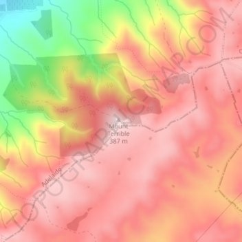
Click on the map to display elevation.
About this map
Name: Adelaide (Sellicks Hill) Weather Radar topographic map, elevation, terrain.
Average elevation: 291 m
Minimum elevation: 82 m
Maximum elevation: 387 m
Other topographic maps
Click on a map to view its topography, its elevation and its terrain.
Happy Valley Reservoir
Australia > South Australia > City of Onkaparinga > Adelaide
Happy Valley Reservoir, Manning Road, Happy Valley, Adelaide, City of Onkaparinga, South Australia, 5159, Australia
Average elevation: 164 m
Happy Valley Reservior
Australia > South Australia > City of Onkaparinga > Adelaide
Happy Valley Reservior, Happy Valley Drive, Happy Valley, Adelaide, City of Onkaparinga, South Australia, 5159, Australia
Average elevation: 173 m
McLaren Vale
Australia > South Australia > City of Onkaparinga > Adelaide
McLaren Vale, Adelaide, City of Onkaparinga, South Australia, 5171, Australia
Average elevation: 90 m
Noarlunga Downs
Australia > South Australia > City of Onkaparinga > Adelaide
Noarlunga Downs, Adelaide, City of Onkaparinga, South Australia, 5168, Australia
Average elevation: 43 m
Seaford Heights
Australia > South Australia > City of Onkaparinga > Adelaide
Seaford Heights, Adelaide, City of Onkaparinga, South Australia, 5169, Australia
Average elevation: 61 m
Aldinga Conservation Park
Australia > South Australia > City of Onkaparinga > Adelaide
Aldinga Conservation Park, Aldinga Beach, Adelaide, City of Onkaparinga, South Australia, 5173, Australia
Average elevation: 16 m
Aberfoyle Park
Australia > South Australia > City of Onkaparinga > Adelaide
Aberfoyle Park, Adelaide, City of Onkaparinga, South Australia, 5159, Australia
Average elevation: 217 m
Happy Valley
Australia > South Australia > City of Onkaparinga > Adelaide
Happy Valley, Adelaide, City of Onkaparinga, South Australia, 5159, Australia
Average elevation: 177 m
Willunga South
Australia > South Australia > City of Onkaparinga > Adelaide
Willunga South, Adelaide, City of Onkaparinga, South Australia, 5172, Australia
Average elevation: 245 m
O'Sullivan Beach
Australia > South Australia > City of Onkaparinga > Adelaide
O'Sullivan Beach, Adelaide, City of Onkaparinga, South Australia, 5166, Australia
Average elevation: 30 m
Sellicks Beach
Australia > South Australia > City of Onkaparinga > Adelaide
Sellicks Beach, Adelaide, City of Onkaparinga, South Australia, 5174, Australia
Average elevation: 45 m
Coromandel Valley
Australia > South Australia > City of Onkaparinga > Adelaide
Coromandel Valley, Adelaide, City of Onkaparinga, South Australia, 5051, Australia
Average elevation: 248 m
Willunga
Australia > South Australia > City of Onkaparinga > Adelaide
Willunga, Adelaide, City of Onkaparinga, South Australia, 5172, Australia
Average elevation: 158 m
Port Willunga
Australia > South Australia > City of Onkaparinga > Adelaide
Port Willunga, Adelaide, City of Onkaparinga, South Australia, 5173, Australia
Average elevation: 22 m
Aldinga Beach
Australia > South Australia > City of Onkaparinga > Adelaide
Aldinga Beach, Adelaide, City of Onkaparinga, South Australia, 5173, Australia
Average elevation: 20 m
Onkaparinga River National Park
Australia > South Australia > City of Onkaparinga > Adelaide
Onkaparinga River National Park, Onkaparinga Hills, Adelaide, City of Onkaparinga, South Australia, 5163, Australia
Average elevation: 139 m
Woodcroft
Australia > South Australia > City of Onkaparinga > Adelaide
Woodcroft, Adelaide, City of Onkaparinga, South Australia, 5162, Australia
Average elevation: 167 m
Morphett Vale
Australia > South Australia > City of Onkaparinga > Adelaide
Morphett Vale, Adelaide, City of Onkaparinga, South Australia, 5162, Australia
Average elevation: 97 m
Port Noarlunga Reef Sanctuary Zone
Australia > South Australia > City of Onkaparinga > Adelaide
Port Noarlunga Reef Sanctuary Zone, Adelaide, City of Onkaparinga, South Australia, Australia
Average elevation: 1 m
McLaren Flat
Australia > South Australia > City of Onkaparinga > Adelaide
McLaren Flat, Adelaide, City of Onkaparinga, South Australia, 5171, Australia
Average elevation: 135 m
Old Reynella
Australia > South Australia > City of Onkaparinga > Adelaide
Old Reynella, Adelaide, City of Onkaparinga, South Australia, 5161, Australia
Average elevation: 115 m
Seaford
Australia > South Australia > City of Onkaparinga > Adelaide
Seaford, Adelaide, City of Onkaparinga, South Australia, 5169, Australia
Average elevation: 23 m
Onkaparinga Hills
Australia > South Australia > City of Onkaparinga > Adelaide
Onkaparinga Hills, Adelaide, City of Onkaparinga, South Australia, 5163, Australia
Average elevation: 179 m
Seaford Meadows
Australia > South Australia > City of Onkaparinga > Adelaide
Seaford Meadows, Adelaide, City of Onkaparinga, South Australia, 5169, Australia
Average elevation: 17 m
Moana
Australia > South Australia > City of Onkaparinga > Adelaide
Moana, Adelaide, City of Onkaparinga, South Australia, 5169, Australia
Average elevation: 20 m
Huntfield Heights
Australia > South Australia > City of Onkaparinga > Adelaide
Huntfield Heights, Adelaide, City of Onkaparinga, South Australia, 5163, Australia
Average elevation: 62 m
The Range
Australia > South Australia > City of Onkaparinga > Adelaide
The Range, Adelaide, City of Onkaparinga, South Australia, 5172, Australia
Average elevation: 283 m
Port Noarlunga South
Australia > South Australia > City of Onkaparinga > Adelaide
Port Noarlunga South, Adelaide, City of Onkaparinga, South Australia, 5167, Australia
Average elevation: 9 m
Port Noarlunga
Australia > South Australia > City of Onkaparinga > Adelaide
Port Noarlunga, Adelaide, City of Onkaparinga, South Australia, 5167, Australia
Average elevation: 9 m
Christies Beach
Australia > South Australia > City of Onkaparinga > Adelaide
Christies Beach, Adelaide, City of Onkaparinga, South Australia, 5165, Australia
Average elevation: 18 m
Seaford Rise
Australia > South Australia > City of Onkaparinga > Adelaide
Seaford Rise, Adelaide, City of Onkaparinga, South Australia, 5169, Australia
Average elevation: 44 m
Aldinga
Australia > South Australia > City of Onkaparinga > Adelaide
Aldinga, Adelaide, City of Onkaparinga, South Australia, 5173, Australia
Average elevation: 33 m
Old Noarlunga
Australia > South Australia > City of Onkaparinga > Adelaide
Old Noarlunga, Adelaide, City of Onkaparinga, South Australia, 5168, Australia
Average elevation: 47 m
Reynella
Australia > South Australia > City of Onkaparinga > Adelaide
Reynella, Adelaide, City of Onkaparinga, South Australia, 5161, Australia
Average elevation: 102 m