
Bourges topographic map
Interactive map
Click on the map to display elevation.
About this map
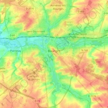
Name: Bourges topographic map, elevation, terrain.
Average elevation: 146 m
Minimum elevation: 118 m
Maximum elevation: 172 m
Other topographic maps
Click on a map to view its topography, its elevation and its terrain.
Cogny
Frankreich > Zentrum-Loiretal > Cher > Cogny
Cogny, Saint-Amand-Montrond, Cher, Zentrum-Loiretal, Metropolitanes Frankreich, 18130, Frankreich
Average elevation: 189 m
Menetou-Salon
Frankreich > Zentrum-Loiretal > Cher
Menetou-Salon, Bourges, Cher, Zentrum-Loiretal, Metropolitanes Frankreich, 18510, Frankreich
Average elevation: 235 m