
Redbourn topographic map
Interactive map
Click on the map to display elevation.
About this map
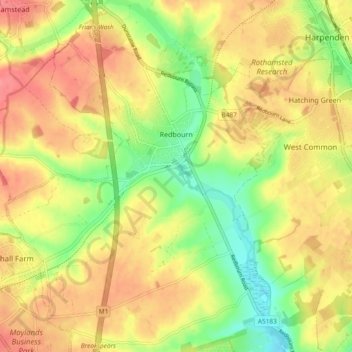
Name: Redbourn topographic map, elevation, terrain.
Location: Redbourn, St Albans, Hertfordshire, Inglaterra, Reino Unido (51.76270 -0.44061 51.82057 -0.36190)
Average elevation: 121 m
Minimum elevation: 82 m
Maximum elevation: 152 m
Other topographic maps
Click on a map to view its topography, its elevation and its terrain.
Harpenden
Reino Unido > Inglaterra > Hertfordshire > St Albans
Harpenden, St Albans, Hertfordshire, Inglaterra, Reino Unido
Average elevation: 119 m