
Thank you for supporting this site ❤️
Make a donation
Make a donation
South Mountains State Park topographic map
Click on the map to display elevation.
Thank you for supporting this site ❤️
Make a donation
Make a donation
South Mountains State Park
While most of the high points average approximately 2000 feet (609 m) in elevation, Buzzard's Roost towers some 3000 feet (914 m) above the surrounding landscape. Elevations within the park itself range from less than 1200 feet (365 m) at points along Jacob's Fork River to 3,000 feet (914 m) on Buzzard's Roost along the park's western boundary.
Thank you for supporting this site ❤️
Make a donation
Make a donation
About this map
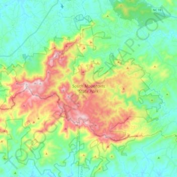
Name: South Mountains State Park topographic map, elevation, terrain.
Average elevation: 498 m
Minimum elevation: 315 m
Maximum elevation: 905 m
Thank you for supporting this site ❤️
Make a donation
Make a donation
Other topographic maps
Click on a map to view its topography, its elevation and its terrain.
Thank you for supporting this site ❤️
Make a donation
Make a donation
Thank you for supporting this site ❤️
Make a donation
Make a donation
Thank you for supporting this site ❤️
Make a donation
Make a donation