
Jochberg topographic map
Interactive map
Click on the map to display elevation.
About this map
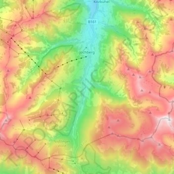
Name: Jochberg topographic map, elevation, terrain.
Location: Jochberg, Bezirk Kitzbühel, 6373, Oostenrijk (47.31131 12.33526 47.40479 12.49860)
Average elevation: 1,527 m
Minimum elevation: 799 m
Maximum elevation: 2,334 m
Other topographic maps
Click on a map to view its topography, its elevation and its terrain.
Kühle Luft
Oostenrijk > Bezirk Kitzbühel > Hopfgarten im Brixental
Kühle Luft, Hopfgarten im Brixental, Bezirk Kitzbühel, 6361, Oostenrijk
Average elevation: 797 m