
Pitec topographic map
Interactive map
Click on the map to display elevation.
About this map
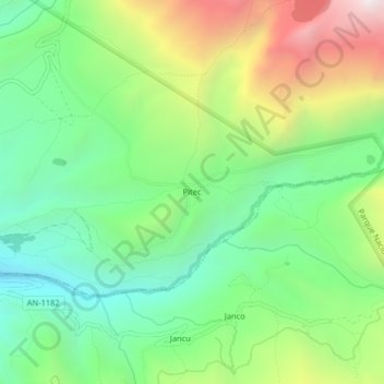
Name: Pitec topographic map, elevation, terrain.
Location: Pitec, Independencia, Huaraz, Ancash, Pérou (-9.52640 -77.46122 -9.48640 -77.42122)
Average elevation: 3,911 m
Minimum elevation: 3,430 m
Maximum elevation: 4,765 m
Other topographic maps
Click on a map to view its topography, its elevation and its terrain.
Laguna Churup
Pérou > Ancash > Independencia
Laguna Churup, Independencia, Huaraz, Ancash, Pérou
Average elevation: 4,524 m