
Les Gottes topographic map
Interactive map
Click on the map to display elevation.
About this map
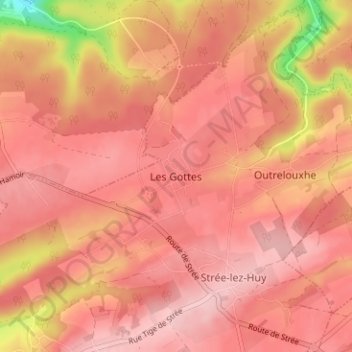
Name: Les Gottes topographic map, elevation, terrain.
Location: Les Gottes, Modave, Hoei, Luik, Wallonië, 4577, België (50.48403 5.29574 50.52403 5.33574)
Average elevation: 231 m
Minimum elevation: 110 m
Maximum elevation: 271 m
Other topographic maps
Click on a map to view its topography, its elevation and its terrain.
Villers-le-Bouillet
Villers-le-Bouillet, Hoei, Luik, Wallonië, 4530, België
Average elevation: 173 m
Seraing-le-Château
Seraing-le-Château, Verlaine, Hoei, Luik, Wallonië, 4537, België
Average elevation: 170 m
Vyle-et-Tharoul
Vyle-et-Tharoul, Marchin, Hoei, Luik, Wallonië, 4570, België
Average elevation: 224 m
La Sarte à Ben
La Sarte à Ben, Hoei, Luik, Wallonië, 4500, België
Average elevation: 173 m
Burnontige
Burnontige, Ferrières, Hoei, Luik, Wallonië, 4190, België
Average elevation: 369 m
Comblain-la-Tour
Comblain-la-Tour, Hamoir, Hoei, Luik, Wallonië, 4180, België
Average elevation: 191 m
Warnant-Dreye
België > Luik > Hoei > Warnant-Dreye
Warnant-Dreye, Hoei, Luik, Wallonië, 4530, België
Average elevation: 165 m
Villers-le-Temple
Villers-le-Temple, Nandrin, Hoei, Luik, Wallonië, 4550, België
Average elevation: 237 m
Vaux-et-Borset
Vaux-et-Borset, Villers-le-Bouillet, Hoei, Luik, Wallonië, 4530, België
Average elevation: 166 m
Chapon-Seraing
Chapon-Seraing, Verlaine, Hoei, Luik, Wallonië, 4537, België
Average elevation: 180 m
Vieuxville
Vieuxville, Ferrières, Hoei, Luik, Wallonië, 4190, België
Average elevation: 215 m
Fize-Fontaine
Fize-Fontaine, Villers-le-Bouillet, Hoei, Luik, Wallonië, 4530, België
Average elevation: 183 m
Vieux-Waleffe
Vieux-Waleffe, Villers-le-Bouillet, Hoei, Luik, Wallonië, 4530, België
Average elevation: 151 m