
Thank you for supporting this site ❤️
Make a donation
Make a donation
Cachaço topographic map
Click on the map to display elevation.
Thank you for supporting this site ❤️
Make a donation
Make a donation
Cachaço
Cachaço is a settlement in the northwestern part of the island of São Nicolau, Cape Verde. It is situated 3 km southwest of Fajã de Baixo and 5 km west of Ribeira Brava. It lies on the national road from Tarrafal de São Nicolau to Ribeira Brava (EN1-SN01). Cachaço lies at about 700 m elevation, at the northeastern foot of Monte Gordo, and partly within the Monte Gordo Natural Park. Several rivers have their source near Cachaço, including the north-flowing Ribeira Grande and the east-flowing Ribeira Brava.
Thank you for supporting this site ❤️
Make a donation
Make a donation
About this map
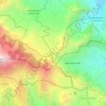
Name: Cachaço topographic map, elevation, terrain.
Average elevation: 613 m
Minimum elevation: 97 m
Maximum elevation: 1,288 m
Thank you for supporting this site ❤️
Make a donation
Make a donation
Other topographic maps
Click on a map to view its topography, its elevation and its terrain.