
Thank you for supporting this site ❤️
Make a donation
Make a donation
Crotière topographic map
Click on the map to display elevation.
Thank you for supporting this site ❤️
Make a donation
Make a donation
About this map
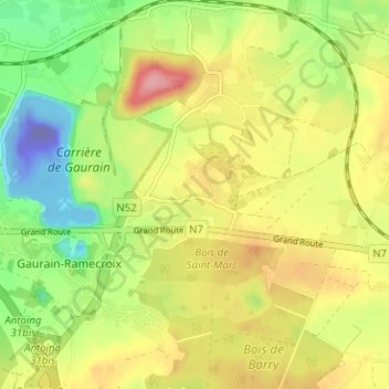
Name: Crotière topographic map, elevation, terrain.
Average elevation: 50 m
Minimum elevation: -186 m
Maximum elevation: 112 m
Thank you for supporting this site ❤️
Make a donation
Make a donation
Other topographic maps
Click on a map to view its topography, its elevation and its terrain.
Parc Marvis
Belgique > Hainaut > Tournai-Mouscron > Tournai > Warchin > Allain
Average elevation: 28 m