
Thank you for supporting this site ❤️
Make a donation
Make a donation
Trevalyn topographic map
Click on the map to display elevation.
Thank you for supporting this site ❤️
Make a donation
Make a donation
About this map
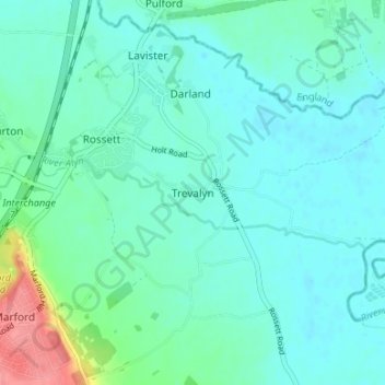
Name: Trevalyn topographic map, elevation, terrain.
Location: Trevalyn, Wrexham, Wales, LL12 0ET, United Kingdom (53.08403 -2.94909 53.12403 -2.90909)
Average elevation: 18 m
Minimum elevation: 4 m
Maximum elevation: 78 m
Thank you for supporting this site ❤️
Make a donation
Make a donation
Other topographic maps
Click on a map to view its topography, its elevation and its terrain.