
Make a donation
Donja Drenova topographic map
Click on the map to display elevation.
Make a donation
About this map
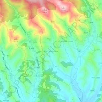
Name: Donja Drenova topographic map, elevation, terrain.
Average elevation: 215 m
Minimum elevation: 137 m
Maximum elevation: 374 m
Make a donation
Other topographic maps
Click on a map to view its topography, its elevation and its terrain.
Make a donation
Make a donation
Make a donation
Make a donation
Jastrebarsko
Jastrebarsko is located in the Prigorje region of Central Croatia, built around the Reka Creek (Croatian: Potok Reka; reka is Kajkavian dialect word for river). On the west, Jastrebarsko is bordered by the Žumberak Mountain (Croatian: Žumberačka gora), a mountain range spreading through southeast Slovenia…
Average elevation: 145 m
Make a donation
Make a donation
Make a donation
Jastrebarsko
Jastrebarsko is located in the Prigorje region of Central Croatia, built around the Reka Creek (Croatian: Potok Reka; reka is Kajkavian dialect word for river). On the west, Jastrebarsko is bordered by the Žumberak Mountain (Croatian: Žumberačka gora), a mountain range spreading through southeast Slovenia…
Average elevation: 145 m
Make a donation