Make a donation
Nagavali topographic map
Click on the map to display elevation.
Make a donation
About this map
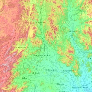
Name: Nagavali topographic map, elevation, terrain.
Location: Nagavali, Andhra Pradesh, India (18.35108 83.31055 19.43164 83.86849)
Average elevation: 401 m
Minimum elevation: 9 m
Maximum elevation: 1,600 m
Make a donation
Other topographic maps
Click on a map to view its topography, its elevation and its terrain.
Visakhapatnam
India > Andhra Pradesh > Visakhapatnam (Urban)
The city is situated between the Eastern Ghats and the Bay of Bengal. The city coordinates lies between 17.7041 N and 83.2977 E. The city's area is 682 km2. The average elevation is 45 metres. Visakhpatnam is situated in Coastal Andhra Region.
Average elevation: 35 m
Make a donation
Anantapuram
Penna, Chithravathi, Pedda Hagari, Chinna Hagari, Thadakaleru and Pandameru are the main rivers. The average elevation is about 1300 feet above the mean sea level. The annual normal rainfall of the district is 508.2 mm. Thus it secures least rainfall when compared to other parts of Andhra Pradesh.
Average elevation: 455 m
Make a donation
Make a donation
Make a donation
Make a donation
Make a donation
Make a donation
East Godavari district
East Godavari occupies an area of 12,805 square kilometres (4,944 sq mi), comparatively equivalent to Indonesia's Sumba Island. The district is bounded on north by Visakhapatnam district, Malkangiri district of Orissa on the northwest by Khammam district and Sukma district of Chhattisgarh, on the east and…
Average elevation: 60 m
Make a donation
Yeguvapeta
India > Andhra Pradesh > Bheemunipatnam > Bheemunipatnam ( Bheemili )
Average elevation: 18 m
Make a donation
Make a donation
Make a donation
Make a donation
Make a donation
Make a donation
Sullurpeta
India > Andhra Pradesh > Sullurpeta
Sullurupeta is located about 77 km east of Tirupati, 90 km south of Nellore and about 83 km north of Chennai, Tamilnadu. It is 16 km west of the world-famous ISRO island Sriharikota, where the Indian rockets are launched. The Pulicat lake separates Sullurupeta and Sriharikota. It has an average elevation of 11…
Average elevation: 4 m
Guntakal
India > Andhra Pradesh > Guntakal
Guntakal is located at 15°10′N 77°23′E / 15.17°N 77.38°E / 15.17; 77.38. It has an average elevation of 432 metres (1,417 ft).
Average elevation: 445 m
Make a donation
Sarada
India > Andhra Pradesh > Chodavaram
The catchment area of the basin is 2,665 square kilometers. It rises at an elevation of 1,000 meters in the Eastern Ghats. It runs eastwards for a distance 122 kilometers and joins the Bay of Bengal.
Average elevation: 222 m
Nellore
India > Andhra Pradesh > Nellore
Nellore is located at 14°26′N 79°59′E / 14.44°N 79.98°E / 14.44; 79.98. It has an average elevation of 18 metres (59 ft).
Average elevation: 17 m
Make a donation
Bobbili
India > Andhra Pradesh > Bobbili
Bobbili is located at 18°34′00″N 83°22′00″E / 18.5667°N 83.3667°E / 18.5667; 83.3667. It has an average elevation of 103 metres (337 feet).
Average elevation: 130 m
Make a donation
Repalle
India > Andhra Pradesh > Repalle
Repalle is located at 16°01′N 80°31′E / 16.01°N 80.51°E / 16.01; 80.51. It has an average elevation of 7 m (23 ft) and situated 10.62 km (6.60 mi). The nearest towns are Tenali in the Guntur district, Ponnur, Bapatla in the Bapatla District and Machilipatnam in the Krishna district.
Average elevation: 5 m
Make a donation
Make a donation
Make a donation
Make a donation
Make a donation
Guntur
India > Andhra Pradesh > Guntur
Guntur is located at 16°17′N 80°26′E / 16.29°N 80.43°E / 16.29; 80.43. It has an average elevation of 33 metres (108 ft) and is situated on the plains. There are few hills in the surrounding suburban areas and Perecherla Reserve Forest is located in the city's north-west. Guntur lies…
Average elevation: 29 m
Ongole
India > Andhra Pradesh > Ongole
Ongole is located at 15.5°N 80.05°E. It has an average elevation of 10 m (33 ft) AMSL and is situated on plains. The city is around 149 kilometres (93 mi) to the southwest of Amaravati, the state capital.
Average elevation: 15 m
Make a donation
Kakinada
India > Andhra Pradesh > Kakinada (Urban)
Kakinada is located at 16°56′N 82°13′E / 16.93°N 82.22°E / 16.93; 82.22. The 82-degrees east longitude passes through the city. It has an average elevation of 2 metres (6 ft), and many areas of the city are below sea level.
Average elevation: 7 m
Make a donation
Make a donation
