
Saint-Leu topographic map
Interactive map
Click on the map to display elevation.
About this map
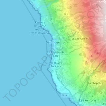
Name: Saint-Leu topographic map, elevation, terrain.
Location: Saint-Leu, Saint-Paul, Réunion, Frankrijk (-21.24924 55.27021 -21.11404 55.41598)
Average elevation: 360 m
Minimum elevation: 0 m
Maximum elevation: 1,822 m
Other topographic maps
Click on a map to view its topography, its elevation and its terrain.
Saint-Pierre
Frankrijk > Réunion > Saint-Pierre
Saint-Pierre, Réunion, Frankrijk
Average elevation: 327 m