
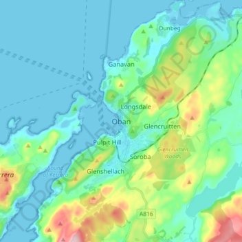
Oban topographic map
Interactive map
Click on the map to display elevation.
About this map
Name: Oban topographic map, elevation, terrain.
Average elevation: 47 m
Minimum elevation: 0 m
Maximum elevation: 237 m
Ein Stück nördlich der Stadt liegt auf einer Anhöhe oberhalb der Straße die Ruine von Dunollie Castle. Der noch in seiner Form erhaltene Bergfried kann betreten werden und die erhöhte Lage ermöglicht eine gute Aussicht auf das Meer.
Other topographic maps
Click on a map to view its topography, its elevation and its terrain.
Island of Danna
Vereinigtes Königreich > Schottland > Argyll and Bute
Island of Danna, Argyll and Bute, Schottland, Vereinigtes Königreich
Average elevation: 9 m
Foreland
Vereinigtes Königreich > Schottland > Argyll and Bute
Foreland, Argyll and Bute, Schottland, PA49 7UU, Vereinigtes Königreich
Average elevation: 32 m
Baile Mòr
Vereinigtes Königreich > Schottland > Argyll and Bute
Baile Mòr, Argyll and Bute, Schottland, PA76 6SJ, Vereinigtes Königreich
Average elevation: 12 m
Appin
Vereinigtes Königreich > Schottland > Argyll and Bute
Appin, Argyll and Bute, Schottland, PA38 4DB, Vereinigtes Königreich
Average elevation: 93 m
North Connel
Vereinigtes Königreich > Schottland > Argyll and Bute
North Connel, Argyll and Bute, Schottland, PA37 1PL, Vereinigtes Königreich
Average elevation: 19 m
Garelochhead
Vereinigtes Königreich > Schottland > Argyll and Bute
Garelochhead, Argyll and Bute, Schottland, G84 0AY, Vereinigtes Königreich
Average elevation: 110 m