Geolocate

North Waltham topographic map

Interactive map

Click on the map to display elevation.

About this map

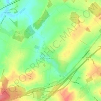
Name: North Waltham topographic map, elevation, terrain.

Location: North Waltham, Basingstoke and Deane, Hampshire, England, United Kingdom (51.19706 -1.22176 51.23347 -1.16713)

Average elevation: 139 m

Minimum elevation: 101 m

Maximum elevation: 185 m

Other topographic maps

Click on a map to view its topography, its elevation and its terrain.

Cocksford Firs East

United Kingdom > England > Hampshire > Basingstoke and Deane > Steventon

Cocksford Firs East, Steventon, Basingstoke and Deane, Hampshire, England, SO21 3BD, United Kingdom

Average elevation: 153 m

Overton

United Kingdom > England > Hampshire > Basingstoke and Deane

Overton, Basingstoke and Deane, Hampshire, England, United Kingdom

Average elevation: 126 m

Woolton Hill

United Kingdom > England > Hampshire > Basingstoke and Deane

Woolton Hill, Basingstoke and Deane, Hampshire, England, RG20 9UZ, United Kingdom

Average elevation: 126 m

Whitchurch

United Kingdom > England > Hampshire > Basingstoke and Deane > Whitchurch

Whitchurch, Basingstoke and Deane, Hampshire, South East England, England, United Kingdom

Average elevation: 108 m

Sherborne St John

United Kingdom > England > Hampshire > Basingstoke and Deane

Sherborne St John, Basingstoke and Deane, Hampshire, England, RG24 9HP, United Kingdom

Average elevation: 92 m

Ellisfield

United Kingdom > England > Hampshire > Basingstoke and Deane

Ellisfield, Basingstoke and Deane, Hampshire, South East England, England, United Kingdom

Average elevation: 176 m

Basingstoke and Deane

United Kingdom > England > Hampshire > Basingstoke and Deane

Basingstoke and Deane, Hampshire, South East England, England, United Kingdom

Average elevation: 115 m

Kingsclere

United Kingdom > England > Hampshire > Basingstoke and Deane

Kingsclere, Basingstoke and Deane, Hampshire, England, United Kingdom

Average elevation: 139 m